Showing posts with label Wellington. Show all posts

Friday, January 2, 2009

Wellington Trip, Part 7 - Final Days

I had planned my Wellington trip so that I could do most of the touristy stuff during the week and then spend time with my friend Rebecca at the weekend when she was off work.

On Saturday we went to Otari Wilton's Bush for a nice walk in the sunshine. The reason I wanted to go there was because it had a canopy walkway, although to be honest it wasn't quite as impressive as I'd hoped. The Reserve itself though was beautiful.


Otari-Wilton's Bush Reserve consists of 100 hectares of native forest and 5 hectares of plant collections. The area has been protected since 1900 when a local landowner Job Wilton fenced it off, thus protecting it from being logged and farmed like the land around it.

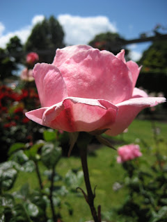
One of the things I have really enjoyed about Wellington was its wealth of green spaces. I've visited Karori Reserve, the Botanical Gardens, Otari-Wilton's Bush and walked through the Town Belt - all these places are within minutes of the city centre. I barely felt like I was in a city at all. All these green spaces and the coastline as well - Wellington has so much beauty!

After our walk, Rebecca took me for a drive around the coastline of the peninsula. We had lunch in a cute little cafe courtyard in a little suburb (I can't remember the name exactly) and then continued our drive round to the Red Rocks Reserve.


In the distant I could just make out the Kaikoura Ranges of the South Island. We didn't go into the Red Rocks Reserve itself, as it required either driving a 4x4 (which we didn't have) or walking several kilometres. This area was really nice though, and there was an informative display in the visitor centre (really a big open shed-like building) about the history of the place.

During the evening Rebecca and I met up with a girl called Steph, who I had met at the hostel, and we went out for dinner at a really nice Asian restaurant called Monsoon Poon, then coffee at a funky cafe. None of us were particularly in the mood for a big night out, but the evening was fun nonetheless, and it was great to see the busy weekend nightlife of Wellington compared to Dunedin!

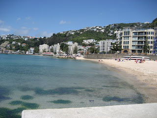
On Sunday, Rebecca and I were being particularly lazy and spent the morning watching the Shortland Street omnibus... but then we decided to make the most of the afternoon sunshine and took our books to the city beach to read and relax. It was really nice just to chill out like that. I really liked the beach, which had warm, safe swimming water, compared to the pretty rough beaches of Dunedin.

Finally it was time for me to fly back to Dunedin. I was actually pretty sad to leave, I'd had a great week exploring Wellington in beautiful, warm weather, which was completely unexpected (everyone warned me about the rubbish weather Wellington has, but apart from the first night I didn't see it at all!) I definitely recommend taking the time to see all Wellington has to offer, rather than just spending a night here, as so many backpackers seemed to do. There were still things I didn't have time to do - I wanted to go out to Matui/Somes Island and Kapiti Island, for example. Well, there is always next time!

Wellington Trip, Part 6 - Botanical Gardens and the Weta Cave

I was pretty exhausted after my hike along the Southern Walkway and so that night I opted to spend relaxing at the hostel. I didn't particularly like the hostel much - earlier in the week it had been full of school kids and so there weren't that many people in my age bracket around. That Thursday night however, I ended up drinking bourbon and cola with some of the hostel staff (mostly backpackers short of money), because it was someone's birthday. He was turning 38, and trying to chat me up... Needless to say I eventually had to escape back to my dorm room.

On Friday morning I travelled up the Cable Car to the Botanical Gardens. The Cable Car has been running since 1902 to give access to a new suburb for all the new people coming to live in Wellington. Otherwise it would have been a steep walk uphill through scrub land. Now the area is, of course, completely different.


Above is the iconic red tram slogging its way up the hill. There are two trams that run up and down the track every 1o minutes.

I spent all morning wandering around the Botanical Gardens. I wanted to visit the Carter Observatory but it was closed for renovations. I did however discover the human sundial close by, which was surprisingly accurate. Below are a few photos of various parts of the Gardens.


I really liked the Peace Garden, with a lovely little waterfall and some welcome shade (it was getting bloody hot by this point!)

The Lady Norwood Rose Garden was in full bloom, full of roses and people admiring them. I took the opportunity to snap a few photos of the pretty flowers.

The Botanical Gardens were nice, but to be honest I was feeling pretty hot and tired (and achy from my long walk) to fully enjoy them. I did like some of the funky statues scattered around the place though.

During the afternoon I decided to go to the Weta Cave out at Miramar. No, this wasn't a cave full of insects but rather the face of Weta Productions, the company who did the special effects in Lord of the Rings. It was a pretty long bus ride out there but it was worth it. The Weta Cave had a little one room museum with pieces from various movies they had worked on, as well as a shop containing pretty expensive but well-crafted merchandise. The selling point for me though, was the brilliant movie in their little cinema. I used to think that Weta was the company that did computer graphics, but I learnt that they had many other faces - including creating weapons, armour, prosthetics, creatures, miniatures, costumes and props.

Having travelled all the way out to Miramar I realised I didn't have any cash to catch the bus back... which meant I had to walk a few kilometres back along the bus route until I found a cash point. Finally making it back to the hostel, I met up with my friend Rebecca, who I was going to spend the weekend with. We spent the evening watching movies on the sofa and catching up. Yey for girlie time!

Wednesday, December 17, 2008

Wellington Trip, Part 5 - Southern Walkway (2)

So now I was halfway through the walk (at least map wise - not actually sure this map has anything close to resembling a scale). Here is the second half anyway:

This part of the map gets more complicated because there are several other walking paths which cross it. They are quite difficult to tell apart on the map, and even more difficult to tell apart in reality, because all the arrows are the same colour (obviously never heard of colour-coding in Wellington...) Hence, I managed to get myself lost 3 times from this point onwards.


The patch of grass just above the cyclist is where I eventually stopped for lunch. Lunch consisted of 2 muesli bars and 3 apricots. I should probably plan these things a little more...

Funny looking trees!

This was my second choice of path, the first turned out not to be a path at all. (First time I got lost, due to fork in the path not being signposted at all!)

The view from Mount Alfred.

At this point my track crisscrossed several others, and because they are all marked with the same colour arrows, I ended up walking along the wrong one. I should have been walking along the ridge line but I was further down in the forest. This meant when I finally worked out where I was, I had a helluva lot of uphill climbing to go. Not fun. I also found arrows pointing to a Lord of the Rings film location, which I followed too, but then those signs disappeared as well.


Finally I made it back onto the right path (in the photo above) and then of course promptly left it to go up to the summit of Mt Victoria. Mt Victoria is one of the most popular lookouts over Wellington and was one of the reasons I chose to do this walk. The views did not disappoint me, but the crowds of bus tourists did...

This is the Byrd Memorial, which honours the memory of Admiral Richard E Byrd, a polar aviation explorer. Due south of this piece of land lies Antarctica (and there is no other land in between).

I can't remember the significance of this rock, but it is at the summit of Mt Victoria.

Buses of tourists showed up while I was here, they all climbed dutifully up from the car park, took some photos and then drove off again. I felt so good for walking all this way to get here, even if I did look like a sweaty, filthy hobo by that point.

I started my walk from somewhere behind that distant headland. I think.

Back down Mt Vic and I was back on the track. I headed towards Charles Plimmer Park where I swiftly lost the track again (although I've no idea how!) and ended up much further down than I was meant to be. I ended up walking back up the main road to Mt Vic until I eventually found the track to lead me back downhill again....


Finally finished!! Only took me about 5 hours.... but that did include losing the track several times. I was really pleased I'd done it, and reached Oriental Parade. It was, however, another couple of km or so back to the hostel, so at this point I cheated and opted for the bus....

All in all, another great day in Wellington. I definitely recommend doing the walk the way I did it - as it is so much nicer to walk towards town, rather than getting out to Island Bay and then having to worry about getting home again.

There are heaps of free walks around the Wellington area - other ones I contemplated were the Northern Walkway and the City to Sea Walkway. Check out this site for more info on the walks around Wellington.

Tuesday, December 16, 2008

Wellington Trip, Part 4 - Southern Walkway (1)

There are a lot of free walks around Wellington, and i-Site has handy little maps for many of them. As I was already pretty broke before I even came to Wellington, I was looking for something free to do. I read about the Southern Walkway and decided that it would be a good way to spend a day, whilst incorporating some other things I wanted to go to, such as the Mount Victoria lookout.

The Southern Walkway is an 11km walk through the Town Belt between Oriental Bay and Island Bay. It is supposed to take about 4-5hrs, which I thought was a bit generous, until I realised how many hills I would have to climb....

I decided to take the bus out to Island Bay and then walk back into Wellington, rather than the more traditional starting point at Oriental Bay. I guess I felt better about walking towards home base than away from it.

Here is the first part of the map:

It is a bit hard to see, but basically the first part of the walk goes along the coastal walk from Island Bay to Houghton Bay and then winds up the hill into the Town Belt. I took way too many photos on this walk, so I'm mostly going to document the walk in photos...

The start (or end) of the walk is Shorland Park - this Band Rotunda was built as a memorial to the 106 soldiers from the area who served in WW1. The following photos show my walk from Island Bay to Houghton Bay:


Then I veered away from the coast up the hill to start the climb up to Mount Albert.


At the top of Mt Albert is this telecommunications tower and some reservoir tanks. Not the prettiest of sights, but if you ignore them then there were some other great views. The walk took me along the ridge then downhill again towards Wellington Zoo.


I was planning on stopping off at the zoo for a break and for lunch, but the walkway actually just takes you around the baboon enclosure at the back, and then away across a playing field to Truby King Park. I didn't really feel like leaving the path to walk down another hill (which I would inevitably have to walk up again..)

Truby King Park is named after Sir Truby King, the founder of the Plunket Society back in 1907. The Nurse Geek in me stirred again, as my first practice placement in NZ was at Plunket, so I got very excited to see the Karitane hospital and factory he built here. Sir Truby King and his wife are also buried here.


The building above is the Plunket factory.

Then I headed through some woodland and zigzagged down to some streets (that's the funny bit at the very top of the map above).


Well, I've now walked the first part of the map. Now onto the second map and a second blog post....